On a navigation several years ago, two soldiers from Sayeret Matkal (elite unit with a storied history, devoted to counter-terrorism and field intelligence gathering) split up at the bottom of a hill, one ascending the summit to collect their nav-point while the other rested below. The soldier resting developed heat stroke. When he radioed his partner about his condition, the soldier climbing the mountain immediately turned and ran back. On his way down, the healthy soldier also began to weaken and developed heat stroke as well. The two soldiers were in serious condition when they were finally evacuated and attended to hours later.
LESSON: Heroism of Sayeret Matkal soldiers done in by overconfidence and excessive individualism (splitting up is against the rules during a two-person navigation).
During a misakem for Duvdevan (elite unit devoted to urban combat) two soldiers were ascending Mount Arbel when one lost track of the other. He failed to realize his partner had disappeared until he reached the summit. By the time the second soldier was found he had already succumbed to heat stroke and died.
LESSON: Duvdevan operatives are cold-hearted killers, even to their own kind.
In the middle of a misakem, several soldiers in Sayeret Tzanchanim hitched rides to a nearby bar, where they drank and made merry until a suspicious patron informed their superiors and the soldiers were apprehended and punished.
LESSON: Sayeret Tzanchanim...good grief.
These are the three tachkirim (case studies) that Israeli special forces soldiers are presented with before misakmim. If there is a better way at capturing the free spirited attitude that reigns in my unit, especially relative to other top units, I would like to hear it. Woot woot, unit pride!
The joke during the last month of my training is that each misakem marks the final exercise for the skills tested in the given misakem. Misakem Krav Maga, for instance, means no more Krav Maga sessions. Misakem Maslul means our entire maslul, shorthand for our fourteen months of training, is finally finished. Even Misakem Tzevet (the team finale) is interpreted in jest as suggesting the team ethic that bound us together through our training can now be abandoned.
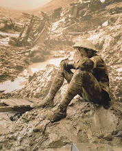
If there is one skill-set my peers are eager to see left behind by the misakmim, it is navigation. Few soldiers favor navigation exercises. Part of the reason is they simply are poor navigators, lacking either the will or the wherewithal to avoid getting lost in unfamiliar surroundings in the dark of the night. The rest of the story is that military navigation is about more than having a feel for hidden valleys and a head for memorizing endless azimuths. Navigation means trekking long distances up and down steep summits in the freezing nighttime wind, shouldering a heavy pack that has no interest in hunting down hidden nav-points. Successful navigators must have the pathfinding mastery of a Davy Crockett, the alpine endurance and iron back of a Nepali Sherpa, and the diligence of a Vilna Gaon. Or they can simply read the following pointers from yours truly, a passionate veteran of many a military navigation.
1) Prep
A navigation does not begin at the designated starting point in the wilderness. It begins the moment the soldier is issued a map and assigned the coordinates for the start, end and nav-points he must collect en route. After labeling these points on his map with a compass-like device (called a madko in IDF slang), the soldier maps out the best route that will lead him to all his points. The ideal route is as short as possible and covers terrain that is easy to cross (flatlands better than hills; wooded undergrowth best to avoid at all costs) and no problem to follow in the wilderness (a route along a valley is far more reliable than one that crisscrosses hills).
The final challenge is to memorize whatever information will insure the soldier can follow his preplanned route in the wilderness. Since IDF navigation training operate without a map and a route may be over forty kilometers, dividing the route into short sections is essential for effective recall. Once a route is sectioned off, soldiers are advised to calculate the azimuth (direction), distance and relevant topographical terrain that will be covered en route. It can also be helpful to record the particular topographical information that indicates the end of a section or the presence of a given nav-point. These four or five categories are best recorded on paper in graph form, though the bottom line is all the information must be memorized and so every soldier has their own preference for imprinting all that information up top. Before sitting for a mandatory brief with an officer, where the soldier describes his entire route from memory as the officer follows along on a map, the soldier must also memorize local settlements and the topographical or man-made (highways) borders to the navigation.
There is no telling how much prep time a soldier will have before a given navigation. So building and memorizing a route sometimes must happen in less than ideal circumstances. The three-night eighty kilometer long navigation for my misakem prat followed two days of prep. While one of these days was shabbat, leading some religious soldiers to refuse to study weekday materials per an especially strict interpretation of religious law, I took full advantage of all the time. I managed to finish writing down all the details of my route before shabbat. And on the day of rest itself, I locked myself in a empty room and orally repeated my entire route step by step. The trick is to make the navigation into a story, and then repeat that story to yourself endlessly until the details on the map are burned into your deepest memory.
2) Paths
A good route is based around topography yet runs along existing paths whenever possible. The reasoning is simple: topography is immutable, so if there is a valley running from points A to B, your route can follow the valley with no fear that the valley has ceased to exist. Paths are unreliable creatures of man-particularly in the dark of night. Yet they are far more agreeable to walk on than the sticky mud and horrid undergrowth that often fill the in-between places. Few maps indicate if a valley is full of thorns and mud. Unless one has hiked the valley in the past, it is best to avoid entering the valley itself and instead find some sort of path that follows alongside.
I suffered from a lack of paths during the early goings of the misakem prat. My first nav-point was impossible to miss: a small hut on the western side of a five-hundred meter long pentagon shaped fish pool. The nav-point was nine kilometers along flat terrain from the start of the navigation, and a series of canals and paths had me confident I would cover this first stretch in good time. Poor logistics and a sea of mud played havoc with such ideas. An expiring bus visa forced the navigation to commence two kilometers east from the point on which I had built my entire route. Starting elsewhere threw my route off from the get-go. The all-too friendly looking canals did not help. Instead of guiding me towards my nav-point, they became impassable sentries I could not skip across in my efforts to salvage my savaged route. My paths also disappeared, swallowed up by pools of mud courtesy of the recent rain.
3) Rain-pants (Hal'fas Tachtone)
If there is any chance you may have to cross open fields over an evening's navigation-regardless of whether it has rained recently or not- it pays to don army issued rain-pants. Otherwise the tall grass and crops will leave you soaked in dew. Wearing rain-pants from the beginning empowers you to take shortcuts across open fields, cut through thorny bushes and even slide down muddy banks.
I was the lone soldier to don rain-pants on the first night of the navigation. My decision paid off when my path to my first nav-point disappeared and I found myself sinking in a dry quicksand like pool of mud. The pants kept the worst of the gunk away. Later the rain-pants allowed me to strike off through a field of two meter high wheat soaked in enough dew to leave my lower half wetter than a raindrop.
4) Live on the Edge - with Caution!
My foreign travel experience has taught me that I take far more risks traveling alone than with a partner. Solo navigation plays to this tendency, encouraging (me at least, to take) wild detours and unnecessary risks. The cautious navigator plays it safe, doing whatever is necessary to stick to his preplanned route. Another sort of navigator--carefree, confident, call it what you will- welcomes unplanned shortcuts.
Shortly after nabbing my first nav-point, my way forward was blocked by the ubiquitous canals. I could have followed my route and walked alongside the waterway until a distant crossing. Instead I sashayed my way across two drainage pipes, dragging my gun, backpack and a half-expressed wish that neither I nor they would drop into the water below. A second crossing later in the navigation went one step further, taking me right into a drainage pipe! Shortly after dawn, I reached a mandatory highway crossing. There was no one present to part the cars and direct me past traffic. Waiting instead was a muck filled drainage pipe, stretching for forty yards underneath the highway and the proscribed way to get to the other side. For the second time I placed my pack and gun before me and pushed and crawled towards the orbit of light waiting on the far side.
5) Return the Way you Came
The straightest line between any two points is not always the quickest. More times than not it pays to return to a main path the same way you left it rather than try a shortcut that covers less ground. The reason is that every path through the wilderness may be riddled with unexpected obstacles. A barbed wire fence, drainage pipes, impassable undergrowth, heck enemy troops if this navigation is no longer just a game. Best to avoid such surprises even if that means covering more ground.
I have learned this lesson the hard way, with two unforgettable valley crossings (my American Eagle and Crouching Tiger Sumo experiences are what I have in mind!) teaching me that trying to take a shortcut through uncharted territory is rarely a good idea. Nonetheless, I made the same error the first night of the misakem prat. Having nabbed my second nav-point with ease, I stood atop a hilltop in sight of my next goal, a nearby mandatory highway crossing. I could double-back the way I had come and descend the hill in the opposite direction of the highway. Or I could pick my way over the rocks and make a bee-line down the hill towards the highway. I chose the latter. My choice almost did me in when in the inky darkness I failed to notice that my chosen descent had come to an end at a fifty foot cliff edge. Barely avoiding the drop, I was forced to take a detour through thorns, over a barbed wire fence and through a cattle barn in order to reach my destination.
6)Rules Don't Mean Anything if You do Not Know When to Break Them
IDF navigation training is full of rules (no maps, no joining with other soldiers, no entering settlements or traversing highways outside of defined crossing points, etc) designed to make sure that the time devoted to navigation is actually spent navigating. Few soldiers follow all the rules all the time. This is especially true in my unit, which as I once wrote even has a song celebrating how black as sin we proudly are. Songs aside, I am not suggesting that the wise navigator break the rules indiscriminately. Navigating with an open map makes a mockery of the very reason for navigation training. That said, there are times when it pays to slip into the black mindset and smudge the rules. Unfortunately, to stand out and stay safe a soldier can not always stay within the narrow confines of proscribed reality. Sometimes he must look out for his own interests and make reality as he wills it.
I crossed into the nether realm of what is allowed midway through the first night of the misakem. En route to a mandatory highway crossing, I checked for cars and crossed the road on my own. I did so in order to nab a nav-point that lay on the other side of the highway. While this point was designed to be my final nav-point of the navigation, collecting it now by quickly slipping across the road shaved ten kilometers off my route. Few of my peers had any intention of investing the hours in searching out more distant nav-points. And so I knew that if I had any interest in hunting down all my nav-points and reaching the end within the same time of my peers, I could not pass up such low lying fruit. As it is, I was one of the very last soldiers to finish the first night's navigation after hunting down every last nav-point, the only soldier to successfully do so.
7) Staying in Character
Commanders always ask that their soldiers embrace the fiction that training exercises are in fact authentic missions, taking place in enemy territory rather than the safe confines of the Negev desert or the Galilee hillsides. The idea is to adopt a more engaged mindset, one that recognizes that the slightest slip-up can have real consequences. Staying in character can be difficult over a grueling three day navigation. But just as in gibushim, when I imagined I was digging for buried treasure during trench digging drills, the payoff for weaving a fantasy into the everyday is immeasurable.
Rather than pretend I was navigating through enemy territory, my choice of fictions during the misakem was Tolkein. Hiking through threatening forests, steely hills and vacant valleys, my mind drifted into realms of hobbits and elves. Like Frodo and Sam, I could see myself on a journey against time, shouldering a burden whose weight only grew as the end grew closer. It was not difficult to slip into the realm of the fantastic during the final stretch of the first night's navigation. The last few kilometers in the valley of Hilazon took me threw an ancient grove of olive trees south of Mount Gilon. The trees were more alive than anything I saw all week, swaying and dancing in the green field like folk dancers, twisting in agony like the most damned creations on Rodin's Gates of Hell. Passing through the grove lit my mind afire even as their aching trunks impelled me to race onward lest my feet take root in the ground and another lost soul join the ranks of their eternal waltz.
8) Stay Hydrated
The most tiresome part of military navigating is the heavy pack strapped to the soldier's back. The weight acts as a bad conscience, willing the soldier to take frequent rests, not waste time on nav-points and make a bee-line for the end. The same voice whispers to reduce the weight by any means possible. Who needs six liters of water, murmurs the pain in your shoulders, three liters will do, especially since one can refill their three-liter waterpack at the frequent mandatory crossing points. Heeding this voice is a very bad idea. What the soldiers who empty their spare water bottles to lighten their load do not realize is that the water they carry is not there to make them tougher but to save their life. Hydration is critical during a long solo navigation when a wrong turn or a logistical snafu by the organizers means the simple soldier must rely on the supplies he carries. Dehydration is one of the deadlier threats on a long navigation. Defeating this enemy means withstanding the pain in your knees and paying regular visits to the water on your back.
If there is one thing my peers have called me out for throughout my service it is my commitment to staying hydrated. I am the soldier who is rarely seen around base without a spare water bottle, who brings extra water on long bus rides so everyone will have what to drink once the trip gets underway. So it was ironic when I ran out of water during the final stretch of the first night's navigation. Nearing the Hilazon Valley, my knees began to shake as my vision blurred, early signs of dehydration. I thought my eyes were playing tricks on me when a flowing stream came into view. As I approached the Shagar riverbed, I reminded myself that many water sources in the wild are polluted and make unsafe drinking water. Yet when I crossed the running water, the clear color and flowing stream deceived me into thinking a few sips would be all right.
These few sips would be my undoing, unleashing a parasite within me that destroyed my misakem prat and made me the laughingstock of my unit. The bitter irony is that twenty meters past the stream I ran into a friendly Bedouin farmer who filled my bottles with clean water and whose silent grandmother made us coffee and insisted I sit and admire the rising sun with them for a good quarter hour. My time with the two Bedouin would in retrospect be the highpoint of my navigation experience as a soldier, closing out a rich chapter in my service that was not always easy yet provided me with many of the most perceptive insights into my brief army career.
Yours Truly
- Shuming
- In Jewish folklore, 'Kefitzat Haderech,' the shortening of the way, is the ability to travel with unnatural speed, to be in one place and then suddenly appear in another. Kefitzat Haderech is now the notes of a former grad student, no longer traveling across Asia as he prepares for life as an Israeli combat soldier. Insights on Garin Tzabar, Gibushim and the Israeli Army.


No comments:
Post a Comment